
South Kingstown Land Trust hosts nine unique and very different public hiking trails throughout our town with more than 14+ miles of carefully groomed trails. These trails have become an important feature of our local quality of life. They offer residents and visitors alike the opportunity to experience and enjoy nature and participate in healthy outdoor activity. Because the trails are all in preserved natural areas, protecting the habitat is very important and only “passive recreation” (activities that minimize human impacts) are permitted. Some examples are observing and photographing nature and wildlife, birdwatching, historic and geologic observation, and of course walking and hiking.
–
Check out SKLT’s awesome Trails StoryMap!
Made with geographic information system ArcGIS, the StoryMap features all the trail info you’ll ever need including topographical info, satellite imagery, landmarks, points of interest, trailhead directions, descriptions, and more.
–
A checklist of birds found on our trails from the RI Bird Atlas 2.0, can be downloaded here.
Search for RI’s diverse groups of butterflies and “odonata” (dragonflies and damselflies) using RI Natural History Survey’s most recent checklists: Checklist of RI Butterflies ~ Checklist of RI Dragonflies & Damselflies
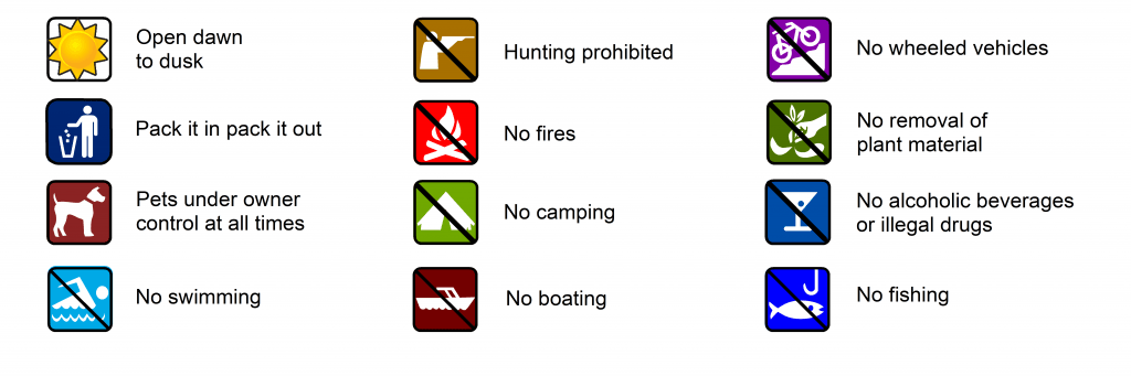
Rules of the trail are posted at each trail head kiosk, included below, and printed on the trail map. Visitors are encouraged to stay on marked trails and remain socially distanced from other hikers encountered on the trail.
Submit trail observations here.
Please leave the trails and the property as found for current and future generations to enjoy.
–
Three of SKLT’s public trails, Weeden Trail, Thewlis Trail, and Tefft, now feature geocaching by Girl Scout Gold Award Recipient Sophia Boardman. Learn more at geocaching.com
–
SKLT WELCOMES YOU BACK TO YAWGOO TRAIL!
We are thrilled to welcome visitors back to Yawgoo Trail following its official reopening on June 12, 2026.
After six years of planning, fundraising, permitting, and restoration work, the trail is once again open for the community to enjoy. This milestone would not have been possible without the generous support of our members, donors, grant funders, and partner organizations.
The restored trail features extensive improvements, including new boardwalks, a bridge crossing Mud Brook, trail rehabilitation, and enhanced protection for the sensitive wetlands and kettle hole bog that make this property so special. Visitors can also explore the new trailhead kiosk and learn more about the natural and cultural history of the area.
We invite you to experience the trail for yourself and see firsthand what your support helped make possible. Whether you’re returning to a favorite walk or discovering Yawgoo for the first time, we hope you’ll enjoy the beauty, wildlife, and scenic views that make this place so unique.
We’d love to hear about your visit. Feel free to share your photos and experiences with us as you explore the trail once again.
Open Space Makes all the Difference…

Alewife Brook Trail
Length: 1.0 mile (Loop)
Points of interest: The Alewife Brook Trail traverses a fine example of typical southern Rhode Island forest. Approximately 79 percent of this property hosts an upland forest canopy of scarlet, black, and white oak, red maple, white and pitch pine, hickory, beech and gray birch. The remaining 21 percent to the south along Alewife Brook is gently sloping wetlands with dense thickets of mountain laurel, rhododendron, sweet pepperbush, red maple, and alder. Both upland and wetland habitats can be observed from the trails here. This 43-acre property was acquired in July 2019 from the Rhode Island Boy Scouts with open space bond funds from RIDEM, the Town of South Kingstown, and with grants from the Bafflin Foundation, the Nature Conservancy, and the Champlin Foundation. Check out a video from the Rhode Island Natural History Survey on some of the flora found at Alewife.
Biscuit City Trail
Length: 0.6 miles
From the North: take either Route 1 or Route 2 to Route 138. From Route 2, take a left onto Route 138 and proceed per directions above. From Route 1 take a right onto Route 138 and proceed for 4 miles to Biscuit City Road. Take a left onto Biscuit City Road and proceed per directions above.
Download Trail Map
Browning Woods Trail
Length: 3 miles
From the North: take Route 2 to Shannock Road (ReStore will be on the corner). Turn left onto Shannock Road and continue 2.7 miles. The parking area is recessed on the left, across from 794 Shannock Road and Moraine Court.
Crawley Preserve Trail System
From the North: take Route 2 to Route 138. Turn right on Route 138 and proceed per directions above.
DuVal Trail System
Length: 7.28 miles (to walk roundtrip both linear and loop trails)
From Route 1 northbound, take the first U-turn after the Moonstone Beach Road exit and proceed per directions above.
Sculpture Trail
Thanks to Troy West and Claudia Flynn for their inspiration and hard work on this project.
From Route 1 southbound: take the U-turn exit for Green Hill Beach Road. Proceed 0.4 miles on Route 1 northbound then proceed per directions above.
Download Trail Map
Thewlis – DAR Trail
Length: 0.8 miles (Loop)
Points of interest: Thewlis Woods features stands of eastern white pine, scarlet oak, and beech. Turkey, coyote, fisher, and many other animals find food and shelter on this property. Harold Thewlis donated 28 acres of wooded upland to The Nature Conservancy in May 1994 who then passed ownership of the property to the South Kingstown Land Trust. The hiking trail was built in 2006 by John Tarasevich as an Eagle Scout project, and generously funded by the Daughters of the American Revolution (DAR).
Weeden Trail
Difficulty: Easy
Length: Approximately 1.5 miles (varies by season and active farming)
Points of interest: Located on a glacial outwash plain, this easy-to-walk trail features pastoral views of stone walls and fields actively cultivated for hay and corn. Visitors may also enjoy views of fields managed for wildlife habitat and a large grove of larch trees. The adjoining “Woodcock Campus” hosts the South Kingstown Land Trust offices and Barn, the site of our annual auction and many other events throughout the year.
Trailhead Directions: From the North or South: take Route 1 to Matunuck Beach Road. Take the second driveway on the right (17 Matunuck Beach Road) and park in the lot for the South Kingstown Land Trust Barn. The trail starts just inside the opening in the stone wall as you enter the parking lot. Download Trail Map. Download a 2018 Plant Inventory of Weeden Farm. Download Stone Wall Geology Tour at Weeden Farm Pamphlet.
Yawgoo Trail – REOPENED JUNE, 2026!
Difficulty: Moderate
Length: 1.9 miles
Points of interest: The Yawgoo Pond Trail takes the hiker by a kettle hole bog, over Mud Brook, and through a grove of stately white pine trees. Yawgoo Trail is also noted for its thick under-story of mountain laurel, especially near the steep banks of the kettle hole, and spectacular views of pristine Yawgoo Pond. Protecting the south and east sides of Yawgoo Pond, this property was acquired in two stages. The first acquisition was a 12.-acre parcel at the south end of Yawgoo Pond, funded through private donations in February 2001. The second acquisition, in October of 2005, preserved 68.3 acres on the east side of the pond. This project received support from the DEM Forest Legacy and Open Space Bond Fund, The Nature Conservancy, The Champlin Foundations, The Bafflin Foundation, and private donations from neighbors.
Following the trail’s closure in 2020, the South Kingstown Land Trust began an extensive process of engineering, design, permitting, and ultimately fundraising, to restore safe public access while protecting the surrounding wetlands and shoreline habitats.
Catalytic funding for the trail reconstruction and wetland bridge project was provided through a grant from the Champlin Foundation. Generous donors matched and surpassed the grant to bring the project across the finish line and allow final reconstruction work to move forward.
As visitors return to the trail, SKLT asks the community to help protect the sensitive ecosystems that make Yawgoo Pond so special. Public access to the shoreline is not permitted to prevent erosion, habitat disturbance, and declining water quality. Visitors are encouraged to remain on designated trails and respect posted signage to help preserve these wetlands, vernal pools, and shoreline habitats for generations to come.
Trailhead Directions: 236 Barbers Pond Rd. West Kingston RI 02892. From the North or South: take Route 2 (South County Trail) to Barber’s Pond Road at the State fishing area. Proceed 0.25 miles to a gravel parking area on the left side of the road.